giovedì 17 novembre 2011

Colli Albani on Nov 19


Meeting
  • Time: 9:00 AM sharp Saturday November 19, 2011.   
  • Place: Largo Passamonti (parking lot behind Verano cemetery) Map
  • Leave comment below to request or offer a ride.
    
Hiking destination
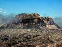
  • Colli Albani (Castel d'Ariano)  
  • Altitude: 891 m
  • Trailhead: Centro Equestre Federale on via del Vivaro N 41° 45.014 E 012° 46.598
    Driving time: about 45' drive from Rome, one way
  • Hiking time:  3 hrs both ways, plus waiting and rest time. Note: there's a chance to split the group and do a longer hike for those who want to walk more.
  • Terrain: Easy, suitable for kids
  • Further trail information 
What you need
  • Food, water (at least 1.5 liters), layered clothing, hiking shoes
  • Sun or rain gear as needed.
Transportation
  • Those who do have a car are encouraged to give others a ride. Post a comment below if you can offer a ride.
  • If you need a ride, it is your responsibility to arrange for a ride directly with the car owners. Post a comment below if you need to request a ride.
  • If you are riding someone's car, please offer to share the cost of gas and highway tolls as a courtesy.
  • Every driver might democratically decide that s/he needs to have dinner after the hike and before driving back to Rome. So, if you have something to do in the evening and need to be back early, consider driving your own car or renting one.
Final green light
Weather conditions can be unpredictable at times. Please check here again 9 PM the night before the hike for the final green light.

Sharing your pictures
After the hike, please click here to upload your pictures to the Castel D'Ariano Album (under construction).
For instructions to upload your pictures for each hike, click here.
Click to view all albums of previous hikes.

lunedì 31 ottobre 2011

Mt. Lucretili on Sunday Nov 13, 2011


Meeting
  • Time: 8:30 AM sharp Sunday November 6, 2011 Changed to Sunday November 13 due to weather. Yes, we're going.   
  • Place: Largo Passamonti (parking lot behind Verano cemetery) Map
  • Leave comment below to request or offer a ride.
    
Hiking destination
  • Mt. Lucretili (Casale di Capo di Porco)  
  • Altitude: 1060 m,  trailhead at 800 m
  • Trailhead: Monte Flavio N 42° 05.841 E 012° 50.757 
  • Driving time: about 1 hr drive from Rome, one way
  • Hiking time:  3 hrs both ways, plus waiting and rest time
  • Terrain: Easy, suitable for kids
  • Further trail information 
What you need
  • Food, water (at least 1.5 liters), layered clothing, hiking shoes
  • Sun or rain gear as needed.
Transportation
  • Those who do have a car are encouraged to give others a ride. Post a comment below if you can offer a ride.
  • If you need a ride, it is your responsibility to arrange for a ride directly with the car owners. Post a comment below if you need to request a ride.
  • If you are riding someone's car, please offer to share the cost of gas and highway tolls as a courtesy.
  • Every driver might democratically decide that s/he needs to have dinner after the hike and before driving back to Rome. So, if you have something to do in the evening and need to be back early, consider driving your own car or renting one.
Final green light
Weather conditions can be unpredictable at times. Please check here again 9 PM the night before the hike for the final green light.

Sharing your pictures
After the hike, please click here to upload your pictures to the Mt Lucretili Album (under construction).
For instructions to upload your pictures for each hike, click here.
Click to view all albums of previous hikes.

mercoledì 12 ottobre 2011

Mt. Meta

Monte Meta West Face
Meeting
  • Time: 7:30 AM sharp Sunday October 16, 2011
  • Place: Largo Passamonti (parking lot behind Verano cemetery) Map
    
Hiking destination
  • Mt. Meta  
  • Altitude: 2242 m,  trailhead at 1403  
  • Trailhead: Picinisco - Prati di Mezzo (1403 m) N 41.66006 E 013.92955
  • Driving time: about 2:15 hr drive from Rome, one way
  • Hiking time:  6 hrs both ways, plus waiting and rest time
  • Terrain: Intermediate to difficult, steep and loose gravels at final section
  • Further trail information English Italian
What you need
  • Food, water (at least 1.5 liters), layered clothing, hiking shoes
  • Rain or sun gear as needed
Transportation
  • Those who do have a car are encouraged to give others a ride. Post a comment below if you can offer a ride.
  • If you need a ride, it is your responsibility to arrange for a ride directly with the car owners. Post a comment below if you need to request a ride.
  • If you are riding someone's car, please offer to share the cost of gas and highway tolls as a courtesy.
  • Every driver might democratically decide that s/he needs to have dinner after the hike and before driving back to Rome. So, if you have something to do in the evening and need to be back early, consider driving your own car or renting one.
Final green light
Weather conditions can be unpredictable at times. Please check here again 9 PM the night before the hike for the final green light.

Sharing your pictures
After the hike, please click here to upload your pictures to the Mt Meta Album (under construction).
For instructions to upload your pictures for each hike, click here.
Click to view all albums of previous hikes.

martedì 20 settembre 2011

Mt Rocca Altiera

Meeting
  • Time: 8:00 AM sharp Sunday September 25, 2011
  • Place: Largo Passamonti (parking lot behind Verano cemetery) Map
  • Alternate meeting point at the trailhead at 10 AM: Map (post a comment below to let us know you're coming.)    
Hiking destination
  • Mt. Rocca Altiera Map 
  • Altitude: 2018 m,  trailhead at 1050
  • Length: 3 hrs each way, but you can stop whenever you want and go back.
  • Trailhead: Settefrati (FR), about 2:15 hr drive from Rome
  • Parking : N 41° 40.787 E 013° 54.578
  • Further trail information
What you need
  • Food, water (at least 1.5 liters), layered clothing, hiking shoes
  • Rain or sun gear as needed
Transportation
  • Ironman can offer 2 seats in his car for those who do not have one. First come first served. E-mail Ironman directly with your name and phone number to reserve a seat and confirm at 9 PM the night before the hike.
  • Those who do have a car are encouraged to give others a ride. Post a comment below if you can offer a ride.
  • If you need a ride, it is your responsibility to arrange for a ride directly with the car owners. Post a comment below if you need to request a ride.
  • If you are riding someone's car, please offer to share the cost of gas and highway tolls as a courtesy
  • Note: every driver might democratically decide that s/he needs to have dinner after the hike and before driving back to Rome. So, if you have something to do in the evening and need to be back early, consider driving your own car or renting one.
Final green light
Weather conditions can be unpredictable at times. Please check here again 9 PM the night before the hike for the final green light.

Sharing your pictures
After the hike, please click here to upload your pictures to the Mt Rocca Altiera Album.
For instructions to upload your pictures for each hike, click here.
Click to view all albums of previous hikes.

venerdì 2 settembre 2011

Mt Velino #2


Photo Album of this hike

Field notes

Meeting
  • Time: 8:00 AM sharp September 10 Saturday 
  • Place: Largo Passamonti (parking lot behind Verano cemetery) Map
  • Alternate meeting point at the trailhead at 9 AM: Map (post a comment below to let us know you're coming.)    
Hiking destination
  • Mt Velino Info 
  • Altitude: 2487 m
  • Length: 4 hrs each way, but you can stop whenever you want and go back.
  • Trailhead: Magliano de' Marsi (AQ), about 1 hr drive from Rome
  • Parking : N 42 08.180 E 13 20.419
  • Further trail information
What you need
  • Food, water, layered clothing, hiking shoes
  • Rain or sun gear as needed
Transportation
  • Ironman can offer 2 seats in his car for those who do not have one. First come first serve. E-mail Ironman directly with your name and phone number to reserve a seat and confirm at 9 PM the night before the hike.
  • Those who do have a car are encouraged to give others a ride. Post a comment below if you can offer a ride.
  • If you need a ride, it is your responsibility to arrange for a ride directly with the car owners. Post a comment below if you need to request a ride.
Final green light
Please check here again after 9 PM Saturday may 28 for the final green light.


Sharing your pictures
After the hike, please click here to upload your pictures to the Mt Velino Album.
For instructions to upload your pictures for each hike, click here.
Click to view all albums of previous hikes.


Reward of 1 euro to whoever finds Ironman's phone, lost on the previous attempt on May 29.

martedì 28 giugno 2011

Rifugio Sebastiani, July 2nd

Meeting
  • Time: 8:00 AM sharp Saturday July 2, 2011
  • Place: Verano cemetery Map
  • Alternate meeting point at the Torninparte exit on the Roma - L'Aquila highway at 8:45 AM:  (post a comment below to let us know you're coming.)    
Hiking destination
  • Rifugio Sebastiani Map 
  • Altitude: 2102 m
  • Length: 3 hrs each way, but you can stop whenever you want and go back.
  • Trailhead: Torninparte (AQ), about 45' drive from Rome
  • Parking : near Ristorante-Albergo Alantino 
  • Further trail information
What you need
  • Food, water, layered clothing, hiking shoes
  • Rain or sun gear as needed
Transportation
  • Ironman can offer 2 seats in his car for those who do not have one. First come first serve. E-mail Ironman directly with your name and phone number to reserve a seat and confirm at 9 PM the night before the hike.
  • Those who do have a car are encouraged to give others a ride. Post a comment below if you can offer a ride.
  • If you need a ride, it is your responsibility to arrange for a ride directly with the car owners. Post a comment below if you need to request a ride.
Final green light
Weather conditions can be unpredictable at times. Please check here again 9 PM the night before the hike for the final green light.

Sharing your pictures
After the hike, please click here to upload your pictures to the Rifugio Sebastiani Album.
For instructions to upload your pictures for each hike, click here.
Click to view all albums of previous hikes.

giovedì 16 giugno 2011

Cima di Vallevona, June 18

Meeting
  • Time: 8:00 AM sharp Saturday June 18, 2011
  • Place: Largo Passamonti (parking lot behind Verano cemetery) Map
  • Alternate meeting point at the trailhead at 8:45 AM: Map (post a comment below to let us know you're coming.)    
Hiking destination
  • Cima di Vallevona Map 
  • Altitude: 1820 m
  • Length: 3 hrs each way, but you can stop whenever you want and go back.
  • Trailhead: Santuario Santa Maria dei Bisognosi, Pereto (AQ), about 1 hr drive from Rome
  • Parking : N 42°02.569' E 13°05.580'
  • Further trail information
What you need
  • Food, water, layered clothing, hiking shoes
  • Rain or sun gear as needed
Transportation
  • Ironman can offer 2 seats in his car for those who do not have one. First come first serve. E-mail Ironman directly with your name and phone number to reserve a seat and confirm at 9 PM the night before the hike.
  • Those who do have a car are encouraged to give others a ride. Post a comment below if you can offer a ride.
  • If you need a ride, it is your responsibility to arrange for a ride directly with the car owners. Post a comment below if you need to request a ride.
Final green light
Weather conditions can be unpredictable at times. Please check here again 9 PM the night before the hike for the final green light.

Sharing your pictures
After the hike, please click here to upload your pictures to the Cima di Vallevona Album.
For instructions to upload your pictures for each hike, click here.
Click to view all albums of previous hikes.

venerdì 27 maggio 2011

Mt Velino


Photo Album of this hike

Field notes

Meeting
  • Time: 8:00 AM sharp May 29 Sunday 
  • Place: Largo Passamonti (parking lot behind Verano cemetery) Map
  • Alternate meeting point at the trailhead at 9 AM: Map (post a comment below to let us know you're coming.)    
Hiking destination
  • Mt Velino Info 
  • Altitude: 2487 m
  • Length: 4 hrs each way, but you can stop whenever you want and go back.
  • Trailhead: Magliano de' Marsi (AQ), about 1 hr drive from Rome
  • Parking : N 42 08.180 E 13 20.419
  • Further trail information
What you need
  • Food, water, layered clothing, hiking shoes
  • Rain or sun gear as needed
Transportation
  • Ironman can offer 2 seats in his car for those who do not have one. First come first serve. E-mail Ironman directly with your name and phone number to reserve a seat and confirm at 9 PM the night before the hike.
  • Those who do have a car are encouraged to give others a ride. Post a comment below if you can offer a ride.
  • If you need a ride, it is your responsibility to arrange for a ride directly with the car owners. Post a comment below if you need to request a ride.
Final green light
Please check here again after 9 PM Saturday may 28 for the final green light.


Sharing your pictures
After the hike, please click here to upload your pictures to the Mt Velino Album.
For instructions to upload your pictures for each hike, click here.
Click to view all albums of previous hikes.

lunedì 4 aprile 2011

Lake Duchessa May 8


Meeting
  • Time: 8:30 AM sharp May 8 Sunday 
  • Place: Largo Passamonti (parking lot behind Verano cemetery) Map
  • Alternate meeting point at the trailhead at 10 AM: Map (post a comment below to let us know you're coming.)    
Hiking destination
  • Lake Duchessa Map 
  • Altitude: 1788 m
  • Length: 3 hrs each way, but you can stop whenever you want and go back.
  • Trailhead: Lucoli (AQ), about 1 hr drive from Rome
  • Parking : N 42 14.492 E 13 21.477
  • Further trail information
What you need
  • Food, water, layered clothing, hiking shoes (for this hike, sneakers are OK)
  • Rain or sun gear as needed
Transportation
  • Ironman can offer 2 seats in his car for those who do not have one. First come first serve. E-mail Ironman directly with your name and phone number to reserve a seat and confirm at 9 PM the night before the hike.
  • Those who do have a car are encouraged to give others a ride. Post a comment below if you can offer a ride.
  • If you need a ride, it is your responsibility to arrange for a ride directly with the car owners. Post a comment below if you need to request a ride.
Final green light
Please check here again after 9 PM Saturday may 6 for the final green light.


Sharing your pictures
After the hike, please click here to upload your pictures to the Lake Duchessa Album.
For instructions to upload your pictures for each hike, click here.
Click to view all albums of previous hikes.

martedì 29 marzo 2011

Mt. Gennaro April 2 Saturday

Pictures
View pictures from this hike in the Mt. Gennaro Album.

Field Notes
Click here to read field notes from this hike.

Meeting
  • Time: 8:30 AM sharp Saturday April 2, 2011
  • Place: Piazzale del Verano Map
Hiking destination
  • Mt. Gennaro Map 
  • Summit: 1271 m
  • Length: 1.5 hrs to the meadows (980 m), then 45 mins to the summit.
  • Trailhead: Palombara Sabina, Convento di San Nicola, about 1 hr drive from Rome
  • Parking : N 42° 02.165 E 012° 49.925
  • Further trail information
What you need
  • Food, water, layered clothing, hiking shoes
  • Rain or sun gear as needed
Transportation
  • Ironman can offer 2 seats in his car for those who do not have one. First come first serve. E-mail Ironman directly with your name and phone number to reserve a seat and confirm at 9 PM the night before the hike.
  • Those who do have a car are encouraged to give others a ride. Post a comment below if you can offer a ride.
  • If you need a ride, it is your responsibility to arrange for a ride directly with the car owners. Post a comment below if you need to request a ride.

Final green light
Weather Goddess worked over time this week. It's green.


Sharing your pictures
After the hike, please click here to upload your pictures to the Mt. Gennaro Album.
For instructions to upload your pictures for each hike, click here.

Field Notes
Click here to read field notes from this hike.

lunedì 28 marzo 2011

2010 Hikes

These are hikes of the Hash House Hikers in 2010. Click the albums to view or upload photos.
For instructions to upload your pictures, click here.

Instructions for uploading pictures to Photobucket

Before you start, please read:
  1. You are uploading your pictures to an external site Photobucket that is linked to this blog for everybody to view. The pictures you upload should be free of copyright.
  2. Please only load pictures that you took during our hikes. There is limited storage space on the website. Please resize your pictures to about 100 KB or less and only upload photos that are worth sharing.
  3. Please make sure you are in the correct album (which is the name of the location plus the date of the hike) when you load your pictures.
  4. "The Leaders" reserve the right to remove pictures that are deemed inappropriate or when the storage limit is exceeded.


Photobucket Uploading for Dummies
  1. Normally you can access the correct album by clicking the upload link on the blog of the particular hike. If you want to access any other albums, please go to http://photobucket.com/, log on and then select the correct album for the hike. Please do not add any new album or sub-album.
  2. User name: hikersgonewild
  3. Password: romehike
  4. Click "Upload Now".
  5. From the dropdown menu of "Upload from", select source of your picture files.
  6. Check "Upload to" for the correct album.
  7. Click "Select photos and videos".
  8. In the pop-up window "Select files...", browse and select the pictures you want to upload.
  9. Hold down the control key to select multiple files. Up to 50 pictures at one time is recommended.
  10. Uploading should take a few minutes. The larger the size or number of pictures, the longer it takes.
  11. When uploading is completed, you will have the opportunity to give each picture a name and a description and add tags to the pictures. This is optional and it is recommended to keep these information as brief as possible.
  12. If you want to indicate the name of the photographer, please add the name as a tag to the pictures.
  13. When you are done, click "Save and continue to my album".
  14. Repeat steps 4-13 if you have more pictures to upload.
  15. Share and enjoy!
For further assistance on uploading to Photobucket, click the "Help" link on the bottom of the Photobucket page, under the "Support" menu.